User:Dragfyre/Media
This page includes self-made work only.
Photos
[edit]Canada
[edit]-
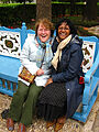
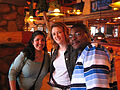 Canadian Bahá'ís
 -

-

-

-

-

-

-

-

-

-

-

-

-

-

-

-
 City map showing the Montreal Bahá'í Centre
 -
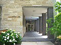
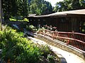
 Montreal Bahá'í Centre
 -
 Montreal Bahá'í Centre
 -
 Montreal Bahá'í Centre
 -
 Montreal Bahá'í Shrine
 -

-

-


Asia
[edit]


Holy Land
[edit]-
 Friends in the Ridván Garden
 -
 Shrine of Bahá'u'lláh
 -

-

-

-
 Shrine of the Báb
 -

-

-

-

-


Other
[edit]-
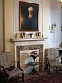
 US National Bahá'í Centre
 -

-
-
 UK National Bahá'í Centre
 -

-

-
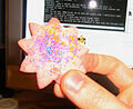 Nine-pointed cookie


Maps
[edit]These maps were created using MapChart, Historicalmapchart and GIMP.
United States
[edit]It's a lot easier to make maps for the United States than for other countries, because there is so much more data available.
Administrative
-
 Regions based on the Tablets of the Divine Plan
 -
 Regional Bahá’í Councils (2024)
 -
 Regional Bahá’í Councils (2016)


Demographic
-
 Largest non-Christian religions (2010).
 -
 Comparison of largest non-Christian religions (2010, 2020).
 -
 Percentage Bahá’í population by county (2020).
 -
 Percentage Bahá’í population by county (2010).


World
[edit]-
 Locations of Bahá’í Houses of Worship.
 -
 Map of National Spiritual Assemblies before and after the Ten Year Crusade
 -
 National Spiritual Assemblies at the beginning of the Ten Year Crusade.
 -
 National Spiritual Assemblies at the end of the Ten Year Crusade.
 -
 National Spiritual Assemblies at the end of the Ten Year Crusade (no text).
 -
 Bahá’í population estimate by UN region (2010).


.png)